ZipCodeMaps.com
Your Source for Accurate
Zip Code, Postal Code Maps & Data
37 YEARS of
Zip Code Mapping
100% of FORTUNE 500
companies as clients
The Only
USPS CASS CERTIFICATION
Compatible Source
Contact Us 1-888-434-6277
Using the Best Data from
Using the Best Data from NAVTEQ, MarketMAPS, Tele Atlas, CLARITAS, USPS and Urban Mapping
Maps for Postmasters
Other great sites
Wall Map Sizes Wall Map Sizes
Finishing Options
Square Bullet Laminated Maps
Square Bullet Mounted Maps
Square Bullet Wooden Rails Finishing Options
Square Bullet Valance
Square Bullet Mark-It Dots
Square Bullet 36x48 in Square Bullet 72x96 in
Square Bullet 48x64 in Square Bullet 90x120 in
Square Bullet 60x80 in Square Bullet 108x144 in
Square Bullet Custom Sizes Available
Map Books Digital Maps
Available sizes
8.5x11 or 11x17
Available in
.pdf or .ai files
The Best Zip Code and Carrier Route Maps
Information
Neighborhood Maps
Neighborhood Maps are valuable business tools. These maps are available in several formats - wall maps for your office; Map Books for quicker reference, easy finding in the car; and Digital Maps for use on your computer. Available for every Neighborhood.

Neighborhood Maps Include:
- Zip Code Index/Grid Locator
- Highways - Interstate/US/State
- States and Counties
- Cities and Towns


Map Styles
Map Styles


Wall Maps
36x48 inches
48x64 inches
60x80 inches
72x96 inches
90x120 inches
108x144 inches
Custom Sizes Available


Finishing Options
Laminated Maps
Spring Rollers
Wooden Rails
Mounted Maps
Valance
Synthetic Paper


Map Books
Available Sizes

8.5x11   11x17


Digital Maps
Available in
.pdf or .ai files
PDF Icon     AI Icon


Report Maps
8.5x11 inches
11x17 inches
17x22 inches
Finishing Options
- Laminated Maps
- Synthetic Paper

bottom background

Neighborhood Maps

Select Your Type of Map
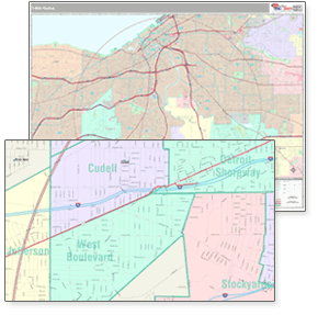
Sample Neighborhood Maps Neighborhood boundaries are more relevant in areas of high urban density where informal spaces are meaningful. The boundaries which we use to create our maps are geographically encoded to provide the precise latitude and longitude for every neighborhood. This information is compiled using thousands of resources that include from a worldwide team of Neighborhood Researchers to representatives of the real estate, tourism and hospitality industries, as well as retail and local media outlets.

Neighborhood boundaries are updated on a periodic basis to assure the most accurate boundaries at any given time. ZIPCodeMaps' expertise and leadership in the mapping world bring you state-of-the-art maps in multiple formats, sizes, and styles. Select the map you need with neighborhood boundaries from our county maps or create your own map using our highly specialized custom mapping services.
 
ZIPCodeMaps.com
1-888-434-6277 |Contact us here.
FREE Shipping* | 100% Satisfaction Guaranteed
Deals Just for You!
Sign up now to be the first to receive
special offers & news!
Sign up now to be the first to receive offers, sales & news!
Shop
Postal Code Maps
Zip Code Maps
Custom Maps
Wall Maps
Digital Maps
Other Great Sites
MarketMAPS.com
mapsales.com
DaVinciBG.com
DeliveryMaps.com
Company Information
About Us
Contact Us
Return Policy
Site Index
View Cart
100% Satisfaction Guaranteed!
Payment Options
MarketMaps.com
MapSales.com
Telephone Code
Headquarters: 10 First Street Wellsboro, PA 16901
West Coast Office: 18005 Skypark Circle, Suite 54 J, Irvine, CA 92614
Legal Notice | Site Index
© 2024 Intelligent Direct, Inc.
VeriSign Secured